
How can we better utilize the underground of Singapore?
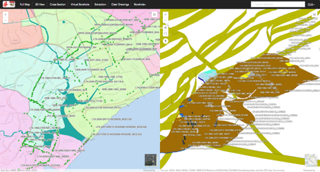
This project aims to establish a web-based 3D Geo-data Modelling and Management System (GeM2S) that will lead to cost savings and increased productivity for future infrastructure or underground construction projects in Singapore. A large amount of geological borehole data and geotechnical testing data have been obtained over the years from various projects. GeM2S can turn these data into a valuable resource to guide future underground developments in Singapore, saving developers a considerable amount of money and time.
This system will enable users to utilize both geological and geotechnical data to enhance the design reliability of underground construction projects. It enables users to visualize underground geological conditions, specially at the potential geological hazard (e.g. faults, thrust, etc.) areas to reduce ground conditions uncertainties. The system can also provide a better guide for site investigation works at new development projects.
Additional multiple sensor types have proven to be able to use in monitoring and collecting detail data for forecast or analyze the possibility of disaster.
Improved security
Enhanced performance
Access from anywhere
Real-time backups
Entirely cloud based
Any number of devices

")